Getting you on the right track
|
What's the best hike for you? Well that all depends on how much time you've got, your fitness, the weather conditions, and what else you'd like to fit in while you are here. We're very happy to help you work out the best combination of walks and lookouts and other attractions to make the most of your time in the Grampians. Check out the info below, but remember that's not everything. If you need help, please call or pop in to reception to talk to us about your options. We'll do everything we can to get you on the right track.
|

|
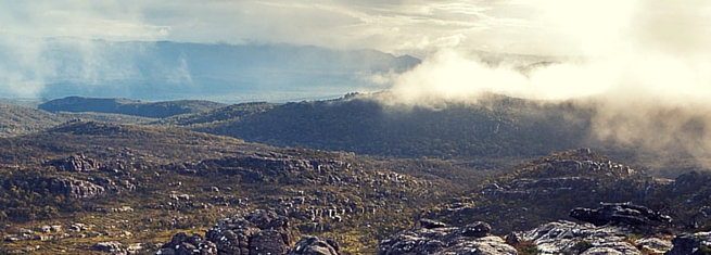
The Pinnacle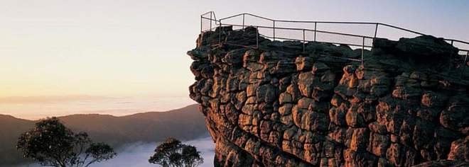
Without doubt the most popular destination in the Grampians, but will you take the high road or the low road?
From the Sundial Carpark it's a medium grade hike of under 2 hours. But like all things in life, the hard way is better. From the Wonderland Carpark it's a little over 2 hours return. It's a bit steeper and a bit further, but totally worth it because this route is much more scenic. Or if you are really up for a challenge, the Wonderland Loop takes in the Venus Baths, Splitters Falls and the Pinnacle. It's much better in the cooler months when there's water in the creeks and falls. If you are going to tackle this one, talk to us first as there are a few things you need to know before you start. |
SUNDIAL ROUTE:
4.2 km return 110m elevation change Medium GOOGLE MAPS WONDERLAND ROUTE: 5.5km return 280m elevation change Medium-hard GOOGLE MAPS WONDERLAND LOOP: 9.2km round trip 498m elevation change Hard (but worth it) |
MacKenzie Falls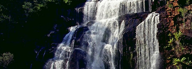
A beautiful waterfall that flows all year round. "It's not Niagara Falls" some guests told us, proving that you can't please everyone. They were right, it's not, but you should go anyway, because it's lovely. Just remember there are twice as many stairs on the way back up as there are on the way down.
BUT, if you turn around at MacKenzie falls and head straight back up the stairs, you've missed something wonderful. Continue along the track to Fish Falls (and extra 3km return trip) and you will treat yourself to one of the best kept secrets in the the Grampians. A lovely walk though the valley with hardly anyone else around you (just don't tell everyone ok). If you don't like the idea of all those stairs (think taking the stairs to the 11th floor of a building), the MacKenzie Falls Lookout Walk offers a lovely alternative. It's a flat, easy walk to a stunning view of the valley. The waterfall is a fair way off, so don't expect to be right on top of it, but the view is striking. |
MACKENZIE FALLS WALK:
2km return (including about 220 stairs) 110m elevation change Medium MACKENZIE FALLS TO FISH FALLS: 3km return (highly recommended) 50m elevation change Easy MACKENZIE FALLS LOOKOUT WALK: 1.9km return (NO stairs) 10m elevation change Easy GOOGLE MAPS (same carpark for all walks) |
The Balconies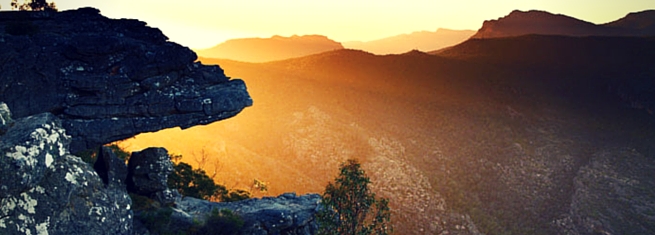
They used to be called "The Jaws of Death" and we're not sure why they changed it, the old name was much more dramatic. And the way people ignore the warning signs and climb out there to sit on the rock, much more apt.
It's a short and pleasant hike from Reid's Lookout (also sometimes spelled Reed Lookout and Reeds Lookout, and no one seems to know which one is correct). Check out the views at Ried's Lookout before you hike to the Balconies. This one is well worth the effort, even if it is just to get a different angle on things. |
Boroka Lookout
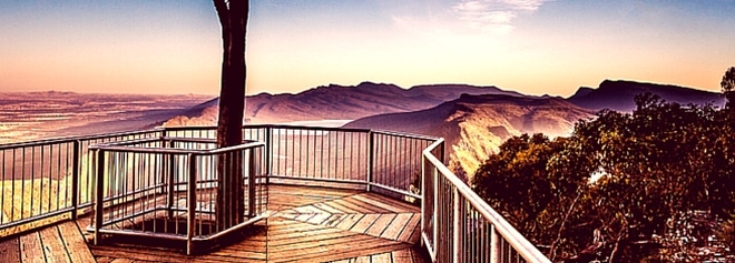
Now of course sometimes you just want the pay-off without all that pesky hiking and sweating and stuff. In which case, the Boroka Lookout is perfect! An easy drive up Mt Difficult Rd (try walking it and you'll understand the name), park your car, and you are there. The perfect spot for sunrise, but almost as stunning at any time of the day.
|
Mt Rosea
OK now we're getting serious. This one is for those who are prepared to work a bit harder for some seriously epic views. It's a solid 4 to 5 (or possibly 6) hours of hiking over some pretty tricky (rocky) mountain tops, but it's totally worth it. This is the best hike in the Grampians.
If you want to do a longer walk, do this one. People come back looking like they've had a mild spiritual experience. BUT If you are going to tackle Mt Rosea, talk to us first as there are a few things you need to know before you start. |
Chataqua Peak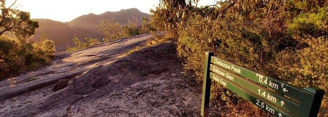
We're reluctant to include this one here because it's one of the most under-rated walks in the whole of the Grampians. Locals love it but it doesn't make it onto most tourist to-do lists, which means you'll practically get the whole mountain to yourself.
Chataqua offers similar views for similar effort to the Pinnacle, but a little bit lower, minus the crowds, and with some really awesome spots where you can just sit on a rock and look at the world below. You can do this as an up and back walk, or as a longer loop including Bullaces Glen and the Venus Baths. On either of these you can also take a short detour to Clematis Falls (but only in the wet months, otherwise it's Clematis Cliff). The starting point for this one is behind the clubhouse at the Rec Reserve. Park your car then walk beside Mt Victory Rd until you see the track on your right. If you run out of footpath and havbe to walk on the road, you've gone too far. |
CHATAQUA PEAK
2.4km 70m elevation change CLEMATIS FALLS A short detour on the way to Chataqua Peak CHATAQUA PEAK LOOP 3.4km 70m elevation change GOOGLE MAPS |
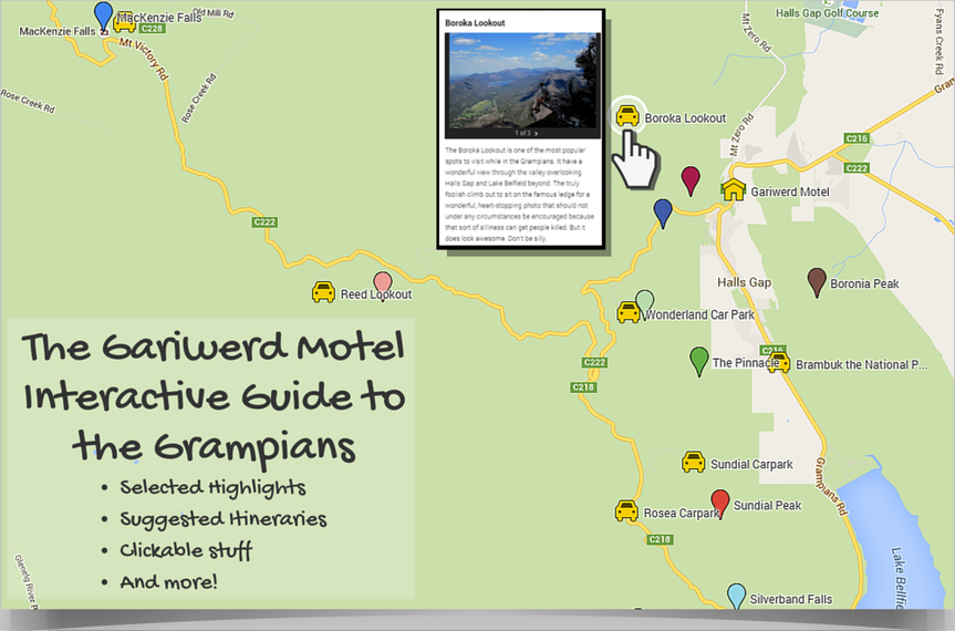
Interactive Google Map
The map below is a bit of an experiment, and is definitely a work in progress. If you find the map helpful, please let us know. If you have any suggestions or feedback, they are very welcome. Unfortunately it can be a bit tricky to navigate on a mobile device, sorry. Don't blame us, that's Google's fault. But they're pretty awesome at stuff so we're sure they are working on it.
Click on the image below to go to our Interactive Google Map. It opens in a new window. Or possibly in the Google Maps App, depending on your phone settings.
Please let us know if you find this useful. Or if you don't, that's useful information too.
Click on the image below to go to our Interactive Google Map. It opens in a new window. Or possibly in the Google Maps App, depending on your phone settings.
Please let us know if you find this useful. Or if you don't, that's useful information too.
What it lacks in design it more than makes up for with content and functionality
A Note About Photos
Some of these photos have been pilfered from the Interwebs. We've tried to find images that are open source and copyright free, but if we've made a mistake, and you see something you think might be yours, please contact us and we'll work out some sort of an arrangement.